|
|
The Trip |
|
|
“Peculiar travel suggestions are
dancing lessons from God" Kurt Vonnegut |
||
|
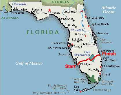
WE DID IT !! We began at Below are maps, our
original paddle plan with daily and culmulative miles (calculated – actual
varied slightly longer), and a list of where we stayed and contact info. |
||
|
|
||
|
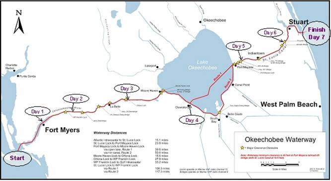
Click on the map below to go to
a “live” pdf picture where you can click along the waterway for more info on
specific spots. It links to a US Army
Corps of Engineers site. You can also
get a lot of info (including the above) on the Okeechobee Waterway on this US
Army Corps of Engineers site : http://www.saj.usace.army.mil/Divisions/Operations/Branches/SFOO/recreation.htm
The Day 1, Day 2, etc.
indicators on the map are where we were after
kayaking the set distance for that day.
They mark where we spent the night.
On Day 5 we kayaked straight across
|
||
|
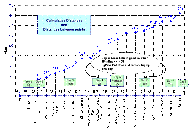
Below is our paddle plan charted with daily (in
green blocks) and culmulative miles. |
||
|
|
||
|
Here is
contact info of places we stayed: Note: We found most of these by using www.maps.google.com and then zooming in on the area we were interested in and typing in “camping”, “motel”, “hotel” – start by going to maps.google.com and type in Ft Myers, FL. Then you can click on the map and move it along the Okeechobee Waterway all the way to the east coast. Zoom in/out as necessary. Stop along the way and look for camp grounds, hotels, etc. by typing in the appropriate phrase. Very cool and useful. Used in congunction with www.terraserver.com to estimate mileage. 1) Best Western Great spot – sandy beach area and rooms very close to beach area. They allowed us to chain the kayaks up just outside our rooms – we recommend bringing locking devices for the entire trip for piece of mind. Be sure to ask for ground floor and follow-up a few times before your trip to ensure the reservations are as expected. 2) Can make reservations on-line – look up the name in Google. 3) Meadowlark Campground/RV park near Ortona Lock phone: 800-889-5636/863-675-2243 4) Roland Martin's 800-473-6766/863-983-3151 5) DuPuis Management area – 1-800-432-2045 Call for special permit to camp along river. Watch for ant hills. Also difficult to climb out of river – a 10 foot ledge. There was an area on the north side of the St Lucie canal around 2 – 3 miles east of Lake Okeechobee and a mile west of Dupuis area that looked good for camping – an open area –no houses, etc but we don’t know who owns it. May be okay to camp along river there if you don’t leave any traces… 6) Port. St. Lucie Lock make reservations through www.reserveamerica.com – cannot call it in. RV sites fill up a year in advance but one tent site was available for us. |
||