|
Suwannee River “Out of the Swamp Tour”
Feb 24 – Mar 3 2007
(If you are planning a
Suwannee River trip, see Resources
at bottom of this page – some very useful info)
We rated
this trip as Moderate/Difficult due to our daily mileage. If we didn’t cover so much distance this
would be Moderate only due to areas of low and fast moving water and the
portage at Big Shoals. The Suwannee River varies by location from Easy,
Moderate, and Difficult due to water levels so call and ask one of the
outfitters about the condition of the area you plan to paddle.
Paddlers:
Stew 51, Tom 58, Craig
31, Dave 48
Note: Tom drove down from Wisconsin, the rest are from various areas
in South
Florida.
Kayaks:
Current Designs Solstice GTS, QCC 700, Current Designs Storm, Current
Designs Solstice GTS same order as paddlers list.
Prior to
the trip we looked at maps, marked what looked like good places to camp, read
everything we could on kayaking/canoeing the Suwannee River.
Emailed a few people who did it and Bill Logan who runs
canoe-suwannee.com for advice. We were
really worried about the water level because several people warned that the
river may be impassable in the northern parts if the water level at White
Springs in below 51 feet above sea level.
For some reason the water level is reported above sea level and at 51
feet at White Springs, that means the water north of there is quite low. So we called outfitters several times to
check on water conditions due to very low water. Bill Logan of the canoe-suwannee.com
website did not think it was a good idea to attempt a launch from Fargo, GA and was adamant that we should
not try to do the whole river in 7 days.
He said take your time and enjoy yourselves instead of racing
through.
Quote
from his email to me “You are making a big mistake
trying to set a darn speed record. WHY the heck would you want to do
that? You won’t have time to enjoy
the trip. You’re making it a hard working chore. Take your time
and do it right, and smell the roses Youngman. You should want to be
able to say, “Damn that was really a fun trip, need to do it again
sometime,” Not “That was way too much,
sure don’t want to do THAT again.” Paddle leisurely, don’t burn up your
paddles and you’ll be glad you did. NOT swift!”
Steve at
Canoe Outpost came right out and said “I don’t think you will make it” when I
told him what we were going to do.
Finally, Wednesday before we left (our trip was to start that
Saturday) I emailed Wendell at the White Springs outfitter (American Canoe
Adventures) and he said “We did a trip from Fargo last weekend no problem” So now I was really excited – I was
feeling down because I wanted to do the whole thing or nothing at all.
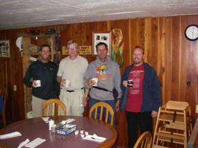
Friday, Feb 23, 2007 Drive to Live Oak, FL
Stew and
I drive in my car to Suwannee Canoe Outpost located in The Spirit of the Suwannee Music Park. 2461 95th Drive, Live Oak FL 32060
1-800-428-4147, website www.canoeoutpost.com
Craig
left a few hours earlier and Tom was already there.
We get
there around 8 pm and say “Hi” to everyone.
I decide not to set up my tent because I was being lazy and try to
sleep in my car. Craig also slept in
his car but was bundled up pretty good and his seats reclined. Stew set up his tent, Tom is in his truck
in luxury on a sleeping pad. It gets
to 37 degrees and I am absolutely freezing.
I had a terrible night with being extremely cold and uncomfortable in
my cramped car but that was my fault.
I should have set up my tent, used my sleeping bag, and dressed for
the weather. I was too lazy to get up
and put on warmer clothes but I did around 3 am since I was so cold. Stew also said he had a bad night due to
the cold. The outfitters told us the
next day that 37 degrees in the campground is a lot colder than 37 degrees
elsewhere. They were right.
Day 1 Saturday, Feb 24, 2007 28.7 miles
Steve
(the owner) and David (one of the guides) from the outfitters show up right
on time – we requested a 6 am 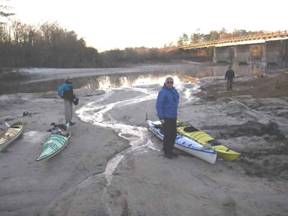 sharp shuttle to Fargo, GA.
We load our kayaks partially packed onto a trailer and throw our stuff
and ourselves into the outfitter’s van.
David drives us to Fargo and stops at a convenience store on
the way so we can load up on coffee.
Ahhh, now the day can begin! sharp shuttle to Fargo, GA.
We load our kayaks partially packed onto a trailer and throw our stuff
and ourselves into the outfitter’s van.
David drives us to Fargo and stops at a convenience store on
the way so we can load up on coffee.
Ahhh, now the day can begin!
We get to
Fargo, GA just before 7:30 am and unload and say goodbye to
David who wishes us luck. We begin
packing our kayaks which is always very frustrating for me for the first
couple of days because things tend to not fit the way they did when planning
for the trip. We finally get started
around 8:40 am and are all excited and relieved that the trip has now
officially begun.
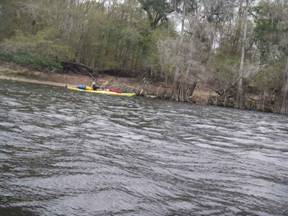
It is
cold out – all of us are wearing warm clothes and layering. The water is shallow as expected and we
cautiously begin our paddle while looking out for rocks and fallen trees in
the river. The river in this area is
very pristine and has numerous turns and bends with little to no signs that
anyone has come this way for some time.
It is absolutely fantastic – better than I had imagined it would be
and I’ll bet it is as good as just about any other river out there.
At one
point someone yells “rapids!” and sure enough there was rushing water
ahead. I was very nervous because I’ve
never been in a kayak – let alone a fully loaded kayak - in rapids before and
I sure as heck didn’t want to tip over.
So, I got behind Tom who is experienced with rapids and he also has a
brand new kayak that he doesn’t want to scrape up! Tom picks his way through and I follow his
path. It was exhilarating and made the
paddle all that more exciting and enjoyable.
We went through several more rapids and/or fast moving water areas
that day.
We push
until 4:30 and find a nice level-looking sandy area to set up
camp. The Suwannee River on the northern parts has lots of
areas made of fine sand that would make great campsites. Most have a slope but there are lots with
level ground at low water levels.
Tents set up fast and we cook dinner and decide that Tom and Stew will
make the water for everyone the next day.
We are surprised that on of our cell phones has a weak signal but good
enough to make a call. We call Tom’s
brother Jeff who is at home in Wisconsin and ask him where he is and when
he will be bringing us beer. Last year
we kayaked across Florida from Sanibel Island to the Atlantic Ocean via the Okeechobee Waterway and
straight across Lake Okeechobee. Jeff followed us
with a truck and supplied us with chairs, water, and beer among other things
at the end of each day at our camp sites.
It was great having him as a support team. Anyway, he thought we were nuts and we all
had a good laugh.
All of us
go to sleep practically right after dinner – tired from paddling but more sleepy
from a restless previous night. I woke
up around midnight with a splitting headache and had to stand up looking at
the stars for around an hour and a half until my headache subsided with the
help of 3 aspirins. Don’t know why but
I always seem to get a headache on day one of a long trip – maybe eye strain
and dehydration…
Day 2 Sunday, February 25, 2007 23.1 miles
Rise and
shine! 5 am we get up, make hot water for
coffee and oatmeal, have breakfast and pack up. Very slow – especially me – I’m brain dead
and can’t think straight or move fast.
We launch around 7:40 am.
We’ll have to work on that.
Another
excellent paddling day – warmer today we don’t need the extra layer of
clothes. Great views and still more rapids/swift
water to contend with to make us smile.
Low water so we have to watch out for rocks and trees in the
water. This also lets us see a lot of
limestone croppings on the river banks that are normally below water. The banks of the river are majestic with
rock formations, trees and their roots exposed and pristine white
sandbars. Stew says it looks a lot
like the scenery from the movie Deliverance.
Partially overcast keeps things a little cooler but very comfortable
for paddling. Making good time –
current maybe 1 mph and finally we make it to Big Shoals – this is where the
fun stops for a while.
 Big Shoals is a class 3 rapid
during higher water and it is not advisable to run them unless you know what
you are doing. Definitely don’t run
them in a loaded boat. They weren’t
passable with our kayaks anyway – Tom said if he had a smaller plastic kayak
he would have attempted them. We
portage the kayaks and find that the shorter quarter-mile portage is not
doable due to the low water so we go further – just under a half-mile to find
a place that is just terrible to launch from but we have no other options. After thinking about it and talking it
over, the portage was probably close to or just under a quarter mile although
it seemed further at the time! Big Shoals is a class 3 rapid
during higher water and it is not advisable to run them unless you know what
you are doing. Definitely don’t run
them in a loaded boat. They weren’t
passable with our kayaks anyway – Tom said if he had a smaller plastic kayak
he would have attempted them. We
portage the kayaks and find that the shorter quarter-mile portage is not
doable due to the low water so we go further – just under a half-mile to find
a place that is just terrible to launch from but we have no other options. After thinking about it and talking it
over, the portage was probably close to or just under a quarter mile although
it seemed further at the time!
Tom
brought a kayak cart just for this and I was glad he did. We strap a kayak to the cart and pull and
push it our roots, rocks and assorted bumps to the top of a cliff where we
will later have to carry the kayaks down over rocks and very slippery
clay-like mud. Tom’s kayak was the
worse due to its weight. I’ll bet it
weighed more than 250 lbs without Tom in it!
Anyway, it took us 2.5 hours to get through the portage and we made it
through without any mishaps except for Tom slipping and falling 4 times –
ouch! If he had slipped while we were
carrying one of the kayaks, it would have been all over for him and the kayak
– nothing but hard, sharp rocks.
We end up
covering 23.1 miles that day and decide to stop at a boat ramp that belongs
to an RV/campground called The Suwannee Valley Campground. It was a very nice place with a laundry
area, (very) small store, bathrooms, showers, and nice residents. The only drawback being a 70-stair climb to
the top of the river bank. Of course I
forgot several items in my kayak several times and had to make 2 or 3 extra
trips up and down those stairs – that’s why I know there are 70 exactly.
Craig
wanted pizza for dinner and asked the girl at the store if she knew of a
pizza place where we could order one for delivery. Her response and a quote we used many times
for the rest our trip was “This is White Springs. We ain’t got nothing in White
Springs.” No pizza so we made our own
dinners but that night they had a root beer float social at the clubhouse and
everyone was invited. It was very
nice. We called Tom’s brother Jeff (in
Wisconsin) again and asked where he was and
what was holding up the beer delivery – another good chuckle but we figured
that was enough and didn’t bother him again on the trip. Did some laundry and called it the night
around 9:30 pm. Light showers
during the night but not bad at all – a good night.
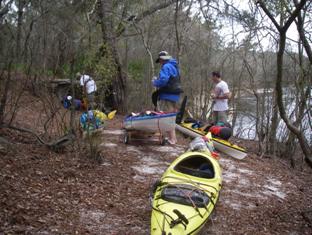
Day 3 Monday, February 26, 2007 29.9 miles
Up at 5 am, make breakfast and coffee and
we’re on our way. Today we shove off
around 7:20 – still slow but with the stairs and still getting used
to the routine - it was acceptable.
Another sunny, warm day that leads us through many more turns, bends
and fantastic sights. More small
rapids and shallow shoals keeps things interesting and now we get some high
rock walls to add to our viewing pleasure.
We stopped at the outfitters (who shuttled us) in the Spirit of the Suwannee park (seemed like it took forever
due to all the turns in the river) where we left our cars and Tom unloads the
kayak cart while the others transfer items to and from their kayaks. I decide not to pick up my fishing pole and
Craig decides to leave his behind because we figure that we wouldn’t have
much opportunity to fish with the distances we wanted to cover daily. We were wrong – there were a few times when
we said “Gee, I wish I had my pole right now.”
No sign
of anyone at the shop – we wanted to let them know our progress so we move
on. We paddle for around 2 hours and
Tom has calculated that we have 5 or 6 more miles to go to get to our next
destination Holton River Camp which would put us on schedule. We were feeling pretty tired – it was a
long day with all the sharp turns and winding river - when all of a sudden
around yet another bend we see the Holton River Camp – around mile 140 on the
Suwannee River map of launch sites.
What a pleasant surprise that was!
Here we thought we had more than an hour to go and we were already
there after kayaking 29.9 miles that day.
This was a very nice set up – the state did a great job putting this
together except for an almost impossible place to store your 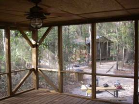 kayaks/canoes/etc – way up the
steep bank – but this was due to the extremely low water. We just pulled our kayaks far up on the
bank and left them there. In
retrospect, we should have tied a rope to them and also to a firm tree –
Craig did but the rest of us didn’t.
The camp is I think 5 wood structures big enough to house 6 people
each with a roof, electricity, and night lights that have motion
detectors. Picnic and campfire areas
and bathrooms with showers are also provided.
The camp hosts were also very nice and knowledgeable. We all slept in the shelters on the wood
floors and heard owls and things scurrying in the bushes. Some of us saw armadillos foraging. A very pleasant night. kayaks/canoes/etc – way up the
steep bank – but this was due to the extremely low water. We just pulled our kayaks far up on the
bank and left them there. In
retrospect, we should have tied a rope to them and also to a firm tree –
Craig did but the rest of us didn’t.
The camp is I think 5 wood structures big enough to house 6 people
each with a roof, electricity, and night lights that have motion
detectors. Picnic and campfire areas
and bathrooms with showers are also provided.
The camp hosts were also very nice and knowledgeable. We all slept in the shelters on the wood
floors and heard owls and things scurrying in the bushes. Some of us saw armadillos foraging. A very pleasant night.
Day 4 Tuesday, February 27, 2007 37.3 miles
Rise and
shine at 5am make breakfast, coffee, pack the yaks and what’s
this? We’re off in the dark just after
6am. Finally I think
we got our morning rhythm going.
Pretty neat paddling in the dark.
I launch into a dead tree in the middle of the river with minimal
impact but it got me to be real cautious while paddling. Around a few bends (actually 4 miles now
that I looked at a map) we pass where the Alapaha River joins the Suwannee and then after another 7 miles we
get to where the Withlocochee River joins the Suwannee and get a welcomed extra push
from the current. The water level is
still extremely low so the current is only around 1.5 mph per my GPS while we
hoped for 2 to 3 when planning this trip.
Still, we felt like we were flying especially when paddling close to
the river bank. I saw our speed go from
a fairly leisurely 5 mph to over 6.3 mph with us not putting in too much
effort. This was neat!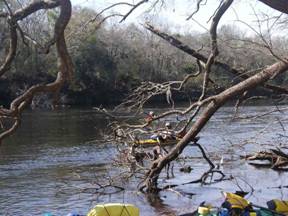
Again, as
with the entire trip, we are blessed with terrific scenery with interesting
trees and rocks along the banks not to mention the water having boils from
time to time from springs spewing out absolutely clean, clear, water. The river still looks like we are in the
middle of nowhere but we start seeing more and more signs of civilization by
way of bridges and stairways coming down to the river. Dave sees all sorts of animals along the
banks that keep turning out to be rocks, sticks, logs, and other non-animal
things. Several times he is yelling at
Tom – “Look, look at that!” or “Tom, over there – it’s an alligator!” Finally Tom goes over and picks up a stick
Dave was pointing to and brings it to him and says “Here’s your
alligator.” Obviously, Dave needs
glasses for distance. He doesn’t wear
them much but maybe he should.
We end up
having our longest day at 37.3 miles and camp at Lafayette Springs around
mile 103 from the Gulf on the river map.
It was another nice campground – only complaint is that the camping
area was pretty far away from the river.
We left our kayaks under the trees and walked our camping gear to the
campground area. The ranger said they
couldn’t allow us to camp outside the campground – next to our kayaks as we
requested. That was okay – we
understand they have to follow rules.
Nice showers and another nice night.
Again we hear owls and what I thought were numerous raccoons talking
with each other. Still not sure that
was raccoons but it sure sounded like them.
Day 5 Wednesday, February 28, 2007 37 miles
Launching
at 6 am was a great idea and this day was particularly cool
because it was very foggy out. It was
an eerie and magical experience being in the water before daylight and in the
fog. It became even more majestic as
the sun rose and slowly burned off the fog.
Our goal was to make it to the Cove restaurant where there is a
campground and the restaurant is known for its food. The scenery was still great with the river
getting a little wider the further south we went. We pass abandoned, broken down bridges, an
old railroad bridge that used to rotate to allow big boats to pass and signs
of other structures worn down by nature over many years. The sky turned overcast and a few bursts of
lightning came a little too close although they were pretty far off. It just makes you edgy knowing you are
pretty much stuck should a storm catch you out on the river with no place to
hide. Some windy conditions but I
still wouldn’t have wanted to be anywhere else at the time.
At
several stops we saw signs with warnings about big jumping fish – we thought it
was a joke at first but then remembered reading about them. People have been hit while motor boating
and jet skiing in the Suwannee River by sturgeon. Actually, I’ll bet the people hit the fish
– the fish was just jumping and the motor craft propelled the people into
it. These sturgeon are protected
because they were almost fished to extinction due to their caviar and nice
white fleshy meat. They signs said the
sturgeon can get to over 200 pounds and do some serious damage should you hit
one. Some locals said they think the
fish get to over 300 pounds and it is a sight to see a big one jump but this
was the wrong time of the year to see them.
Stew and Dave were paddling close together and talking when a large 4
or 5 foot sturgeon breached and landed around 50 feet in front of them. That was really neat and they got a good
look at the prehistoric looking fish.
On one of
our breaks we saw some people at a boat ramp and asked how far to the Cove
restaurant. They said it was only open
Thursday through Sunday (today is Wednesday!) and our hearts sank. We finally make it to the restaurant around
3 pm and sure enough it was closed (open Friday thru Sunday
only) and no signs of people or campers.
We decide to push on until 4 or 4:30 and see where we end up. As luck would have it, we find a boat ramp
with a very nice area for camping next to it.
Some locals say people camp there all the time so we feel good about
this spot. It is around mile 67 on the
river map. Another 37-mile day under
our belts and for the first time we now know that we will be able to complete
our trip on time with the extra miles from the last two days.
We still
wanted pizza and some nice local couple coming back from a boat trip gave us
their phone number and 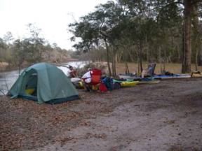 we called them after they got home
for the local pizza take-out number.
As luck would have it, the pizza place closed some time ago. Oh well, crank up the stoves and make our
camp dinners. A very nice, friendly
local man comes up to us and starts talking to us while we are fixing our
dinners. His name is George and he
pulls up his chair. He tells us a
story about a memorial about 60 feet from our campsites. There was a stone that read something about
a “Chief Leroy” so I had asked George about it. He said the guy was driving at a high rate
of speed and he hit a tree so hard “it split his feet.” I didn’t ask him to explain… Anyway the road is straight and around 7
miles long and ends at the Suwannee River – the tree stopped him from
reaching the river by about 20 feet.
We also used that quote many times during our trip. we called them after they got home
for the local pizza take-out number.
As luck would have it, the pizza place closed some time ago. Oh well, crank up the stoves and make our
camp dinners. A very nice, friendly
local man comes up to us and starts talking to us while we are fixing our
dinners. His name is George and he
pulls up his chair. He tells us a
story about a memorial about 60 feet from our campsites. There was a stone that read something about
a “Chief Leroy” so I had asked George about it. He said the guy was driving at a high rate
of speed and he hit a tree so hard “it split his feet.” I didn’t ask him to explain… Anyway the road is straight and around 7
miles long and ends at the Suwannee River – the tree stopped him from
reaching the river by about 20 feet.
We also used that quote many times during our trip.
That
evening 8 to 10 pickup trucks arrive and everyone gets out and drinks a
beer or two and talks. Pretty neat –
like an informal social that I’m sure they do all the time. They stay maybe an hour and a half and then
leave. We have the place to ourselves
except for a van that drives quickly through the grass at around 1 am.
Another great place to camp – we were extremely fortunate at all of
our campsites this trip.
Day 6 Thursday, March 1, 2007 32 miles
Our early
routine has become just that – all of us are up at 5 am preparing and eating breakfast
and packing and ready to launch at 6 am.
Another nice day – at first.
The river is wider in this area but the scenery is still fantastic. We preferred the more narrow parts of the
northern half of the river but this was also beautiful. The winds picked up and seemed to always be
in our faces at around 15 to 25 mph, even with the river winding all the
time. There were times when we were too
close to lightning and couldn’t decide whether it was better to be out in the
middle of the river or near the sides with the tall trees. We all separated somewhat (better that only
one of us gets hit than the whole group!) and paddled fast to get out from
under the edge of the storm where the bulk of the lightning was. Mostly overcast day with occasional showers
and we were getting tired of the wind although we were still making very good
time per my GPS at over 4 mph.
Craig was
having problems with blisters and especially the wind since he was the only
one in a plastic kayak and it had things strapped all over the top. When a gust came down the river – and it
really blew hard when it got between the banks due to a venturi effect - you
could see him slow down and even get pushed sideways at times. Boy was I glad I was in my Solstice. I too had blisters and was trying to ignore
them and hoped they wouldn’t get infected – they didn’t and they actually
became hard by the end of our trip.
The wind was irritating all of us but having the GPS made us feel
better because we could monitor how fast we were going and it still was in
the 4 mph range.
 We finally arrive at Fanning
Springs. It has a nice campground but
again, you have to carry the kayaks a bit to the camping area – but not too
far. When we went to pay for the camp
site the rangers and everyone in the office started telling us how we were
under severe weather warnings with the possibility of tornadoes. They even showed us an on-line weather map
where the worst weather shown in multiple red squares was over our area. It even had two red squares overlapping
right over us. Just great – we are all
tired with our tents set up under giant 100-year old oak trees. Well, Fanning Springs is located in an
actual town so we walked across the street and ate at a barbeque place. We ordered too much to eat and all of us
ate a little too much but it was good to have “real” food for a change. On the way back from the restaurant, Dave
found a snake by the water – either a baby moccasin or a brown water
snake. Of course he picked it up with
a stick and did his best Steve Irwin imitation. Tom being from Wisconsin wanted nothing to do with it so
he scurried off pretty fast when Dave approached. We let the snake go right where we found
it. We finally arrive at Fanning
Springs. It has a nice campground but
again, you have to carry the kayaks a bit to the camping area – but not too
far. When we went to pay for the camp
site the rangers and everyone in the office started telling us how we were
under severe weather warnings with the possibility of tornadoes. They even showed us an on-line weather map
where the worst weather shown in multiple red squares was over our area. It even had two red squares overlapping
right over us. Just great – we are all
tired with our tents set up under giant 100-year old oak trees. Well, Fanning Springs is located in an
actual town so we walked across the street and ate at a barbeque place. We ordered too much to eat and all of us
ate a little too much but it was good to have “real” food for a change. On the way back from the restaurant, Dave
found a snake by the water – either a baby moccasin or a brown water
snake. Of course he picked it up with
a stick and did his best Steve Irwin imitation. Tom being from Wisconsin wanted nothing to do with it so
he scurried off pretty fast when Dave approached. We let the snake go right where we found
it.
When we
got back to the campground the winds were picking up and the sky didn’t look
so good. We spent some time walking
around the springs and sat at a shelter at the end of a boardwalk. Dave went to the river to look for Indian
arrow heads because he promised his wife he would – didn’t find any. The good part was that while down by the
river Dave picked up a stick and was able to reach Tom’s legs about 12 feet
above him. Tom screamed and Dave
laughed harder than he had in a long time.
It was funny but Dave was well aware that Tom also is good at
practical jokes and was wary the rest of the trip although Tom never went for
the revenge.
As night
approached, we decided to move our tents to a big solid-looking outdoor stage
that was made of wood and had a roof.
Everyone was glad they did and the rangers even said it was okay due
to the storm threat. It was a good
idea and we were happy because it was very windy and rained on and off
throughout the night. The next morning
we were dry. Tornadoes did hit just
north of us and I think a few people were killed in the storms so we were
very lucky.
Day 7 Friday, March 2, 2007 30 miles
It is
raining when we get up at 5 am – great timing. Quick breakfast and we wait out the storm –
no hurry today because we only need to do 30 miles to get to the city of Suwannee.
We begin to pack around 7:00 am and use a tarp to cover ourselves
and stuff as we pack our kayaks. Today
is a cold, rainy day with that dab gum lightning again. It was still another great day to be out on
the water in a kayak – we were enjoying every minute of this trip. As long as we were paddling, we weren’t
cold and actually had to remove some clothing at times. Then when we’d stop for a break, we would
start shivering again. We pass by
still more pristine river and now we are starting to see more development but
sparse. The river is wide here too as
it is for the rest of our trip to the Gulf.
We
stopped at Manatee Springs and carefully got out on a floating, metal boat
dock. Here is where we really caught a
chill – very rainy, windy, and cold – but no lightning. We explore the park a little and Dave is
stopped by a guy (we later nickname “Scary Guy” who insists that we need to
“respect the Suwannee” with all the dangers that abound, etc. I think he meant well but didn’t like
Dave’s happy-go-lucky attitude about doing the trip. He warned of alligators as big as your
kayak (our kayaks are 18 feet long) and rough waters at the mouth where the
Gulf meets the river that takes people’s lives every year. He even went as far to say “Nothing
personal but sometimes I hang around a little while just to see what happens
to people like you.” I was a little
intimidated by him but mainly just wanted to get away from him to try and get
warm and be happy-go-lucky again.
Finally
we leave Manatee Springs – I say finally because we were all getting pretty
cold with not paddling. As we leave we
paddle toward the springs and over around 5 baby manatees which scary guy
pointed out to us earlier. We passed
under the boardwalk which had buzzards lined up along the rails – not such a
good omen. Scary Guy watches us pass
by. He was also helpful because he
told us of a place to stay when we get to the city of Suwannee.
We were told about the place by other park rangers and he also knew
the owner who was currently living on the property and gave us some good
advice.
Along the
way we pass a house boat with two women on board. We wave and start talking with them. They knew about us because they read about
our trip in the paper as well as our trip last year. Their names were Amy and 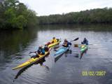 Carol and one was from Manchester, England and one from Ohio.
They took pictures of us and even emailed them to us after the trip
(one is on our website). We were
invited in for tea which was very tempting on this cold, dreary day but it
was getting late and we still had several hours or more of paddling to do. I think Craig was about to cry when we said
we couldn’t stop but in this area, if we didn’t make it to the city of Suwannee, there is no place to stop – only
swamp. Carol and one was from Manchester, England and one from Ohio.
They took pictures of us and even emailed them to us after the trip
(one is on our website). We were
invited in for tea which was very tempting on this cold, dreary day but it
was getting late and we still had several hours or more of paddling to do. I think Craig was about to cry when we said
we couldn’t stop but in this area, if we didn’t make it to the city of Suwannee, there is no place to stop – only
swamp.
Well, we
make it to Suwannee, Florida and were tempted to continue to
the Gulf just to say we did it in 7 days but decided it was best to stop
since it was close to 3 pm and we weren’t sure if it was 7
or 14 miles round-trip. We find the
old Angler’s Resort – it is falling apart because the owner’s husband died
and they had sold it to the state which will be making another wonderful
river camp out of the property. It was
sad to hear the elderly lady (Joy was her name) tell the story of how she and
her husband moved there and ran the place for a number of years before his
death. Now she was in the process of
moving. She graciously allowed us to
stay on the property – it was still hers for another week - when we told her
we had no other place to go. It was
drizzling so we decided to set up our tents in an old fish house with a wood
roof, cement floors and screens. This
actually was in good shape and newer than the rest of the buildings.
We ate at
a restaurant just down the street – Sarah’s I think. It was an excellent meal and a celebration
that we had actually made it! The
night was uneventful and we were glad we stayed in the fish house because it
rained and there were biting gnats outside.
Day 8 Saturday, March 2, 2007 7 miles
 We get up around 5 am and go to the restaurant again
for breakfast which was also great and then got in our kayaks for the grand
finale. We paddled around 3 1/2 miles
to the Gulf
of Mexico,
took pictures and leisurely paddled back.
None of us wanted the trip to be over – it seemed way too short in
time - but it was and each of us started thinking about getting back home. Packed up and started waiting for our ride
back. Stew and Dave went back to the
restaurant and got hamburgers and fries.
Dave remarked that that was one if not the best hamburger he ever had
and the fries were also absolutely great.
The outfitters picked us up around 1 pm – we had called and asked that
they come early – previous was 3pm planned pick-up. Nice ride back – around 2 hours. Tom and Stew nod off more than a few times
and we got pictures to prove it. We get up around 5 am and go to the restaurant again
for breakfast which was also great and then got in our kayaks for the grand
finale. We paddled around 3 1/2 miles
to the Gulf
of Mexico,
took pictures and leisurely paddled back.
None of us wanted the trip to be over – it seemed way too short in
time - but it was and each of us started thinking about getting back home. Packed up and started waiting for our ride
back. Stew and Dave went back to the
restaurant and got hamburgers and fries.
Dave remarked that that was one if not the best hamburger he ever had
and the fries were also absolutely great.
The outfitters picked us up around 1 pm – we had called and asked that
they come early – previous was 3pm planned pick-up. Nice ride back – around 2 hours. Tom and Stew nod off more than a few times
and we got pictures to prove it.
We loaded
our kayaks on their trailer and Tom decided to load his while still fully
packed which turned out to be a not-so-good decision. His kayak got some nasty dings in it from
the long, bumpy ride. What made it
worse was his kayak was a brand new QCC 700.
He took it back to the factory for repair since he lives around 100
miles from them. They are very nice,
talented people and did a fantastic job repairing the kayak – looks good as
new.
The next
hour we prepare our vehicles and load our kayaks and other stuff for the ride
home. A little melancholy in the air
knowing our adventure has come to an end.
We didn’t want it to end. We
all caravan and eat dinner at a Cracker Barrel along the highway and then say
our good byes and head home.
Wow. What a great trip! 225 miles of kayaking with awesome
experiences with friends, people we met, and lots of individual time alone
paddling as desired/needed. A big
challenge with rich rewards of accomplishment but mainly fond memories. I’m ready for our next trip!
The best advice I can give is to
plan a trip and JUST DO IT! - our trip was awesome and something I never
thought I could or would do just a few years ago. The trip was over too soon and each
commented that they would gladly do it again.
Resources:
A MUST:
Call Suwannee River Water Management District 800 226-1066 and request
several “Boat Ramps and Canoe Launches” maps of the river (these have mile
markers on them every mile and places of interest like potential camp
sites. Ask for any other brochures
they have that may help for your trip planning – a good one is Suwannee River
Wilderness Trail brochure. The people
there are very nice and helpful.
Website: http://www.srwmd.state.fl.us/
Get the
Suwannee River Wilderness Trail brochure from Suwannee River Wilderness Trail
800
868-9914 and on the web www.SuwanneeRiver.com There is a National Geographic Destination
Map of the Suwannee River Wilderness Trail too that is pretty good. Not sure which organization sent that to us
– ask for it.
We were
very happy with The Canoe Outpost in the Spirit of the Suwannee Park in Live Oak. Great for leaving your car and getting a
shuttle to launch site and pick up.
Suwannee Canoe Outpost
2461 95th Drive, Live Oak FL 32060
800-428-4147
(800 number not listed on their website).
They have a website too www.canoeoutpost.com/Suwannee/outpost.htm
Visit
these web resources and Google the Suwannee River for more info.
www.aca1.com - American Canoe Adventures in White Springs – Wendell was very
helpful and knowledgeable and they also offer shuttle service. His positive email two days before our trip
sealed our resolve to start in Fargo, GA even with low water.
http://paddleacrossflorida.home.att.net Our website for more photos (not sure how
long it will be up)
www.canoe-suwannee.com
– Bill Logan’s site
We also
used maps.google.com to get a better idea of the terrain and research as well
as just plugging in “Suwannee River” and “Suwannee River Wilderness
Trail” into Goggle.com.
|