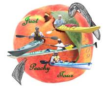
 The
“Just Peachy Tour” was yet another interesting and amazing kayak expedition
trip. The trip was conceived by Dave after exchanging emails with an
outdoor writer named Johnny Malloy. Johnny was put in contact with Dave
by a mutual friend because he wanted some information for a trip he was
planning to
The
“Just Peachy Tour” was yet another interesting and amazing kayak expedition
trip. The trip was conceived by Dave after exchanging emails with an
outdoor writer named Johnny Malloy. Johnny was put in contact with Dave
by a mutual friend because he wanted some information for a trip he was
planning to
So Dave began doing research on the
“The third largest
contributor of freshwater to the
Dave’s plan called
for adding some mileage on the
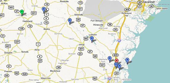
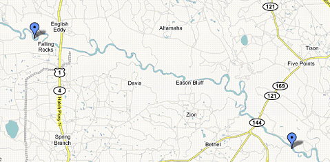
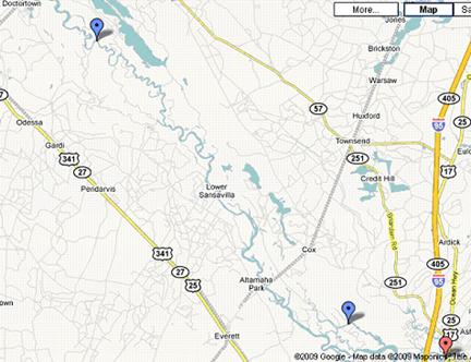
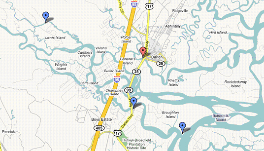
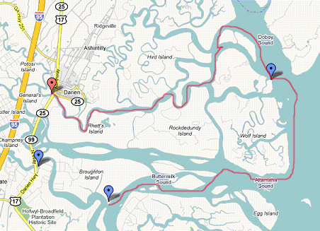
Map of our trip start = green point at
Blue markers are our campsites and some stops near/along the coast.
This year our group featured a new member, Sam who saw some
of Dave’s posts on the Watertribe website concerning long distance
kayaking. He wanted to hook up with people of similar skills and
interests. Dave put him in touch with Jack who lives closer to Sam and
they started paddling on weekends. Jack is an original member of the
Paddle Across Florida team and also joined us on this
trip. Sam fit in perfectly and we were lucky to have him aboard.
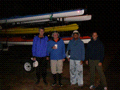
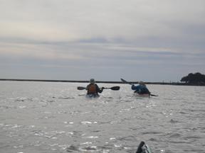
The other usual suspects were Stew, Dave, and our cheesehead buddy from
We met at Jack’s home in Hobe Sound at
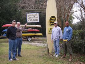
We prearranged with Danny of Altamaha Coastal Tours to
shuttle us from
The drive to
 We arrive at
Day 1 25.5 miles
Note where the two rivers combine (the
confluence) to form the
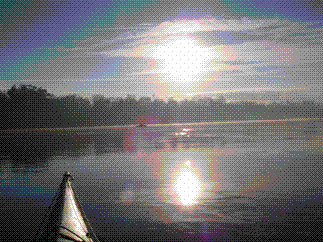
Right after launch of a new trip is one of my favorite
times. Everything seems good and all the stress melts away. We’re
on our way - it is exhilarating and a great feeling. The river we are on
is the
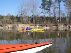 The
river banks are strewn with trees caught in the grips of winter. Oak,
cypress, and pine were the ones I could identify. I’m sure there were
lots of others like hardwoods and bushes of all types. Most of the trees
had grey to brown leaves or were bare and there were pine trees whose green
features seemed to jump out from the wintry backdrop. We saw lots of nice
sandbars and small, sandy bluffs that rise four feet out of the water.
Just fantastic scenery especially coupled with the excitement of a new trip
just under way and the refreshing coolness of the morning air.
The
river banks are strewn with trees caught in the grips of winter. Oak,
cypress, and pine were the ones I could identify. I’m sure there were
lots of others like hardwoods and bushes of all types. Most of the trees
had grey to brown leaves or were bare and there were pine trees whose green
features seemed to jump out from the wintry backdrop. We saw lots of nice
sandbars and small, sandy bluffs that rise four feet out of the water.
Just fantastic scenery especially coupled with the excitement of a new trip
just under way and the refreshing coolness of the morning air.
We reach the confluence after two and a half hours of
paddling and a break. We didn’t know what to expect – swirling, crazy
currents and eddies or what? It turned out to be just an intersection
where two rivers meet. Some interesting feedback currents that I’m sure
would be neat when the rivers are really running. We turn into the
 Just
before
Just
before
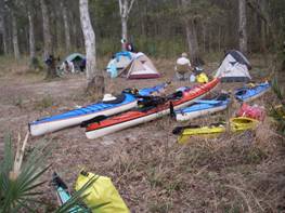
Sam takes on the role of fire maker and sets up a fire pit
and collects wood. The rest of us helped a little. I must say that
the fires we had nightly were a major highlight of our trip experience.
Thanks Sam !! We explored the sandbar and found
deer, raccoon, bird and what we think were some kind of large wild cat foot
prints. That night we heard owls, coyotes, and pigs in the
distance. Beautiful sleeping weather in the 30s and a
clear night with almost a full moon. The snoring began around
Day 2 31.8 miles
 Push
off time is around
Push
off time is around
It was nice except everything got a little bit of mud on it especially with the morning dew converting dry mud into wet mud. Not too bad though. Another wonderful fire by way of Sam, we eat, tell stories and off to snoredom. Again we hear owls that night and are treated to a clear sky in which we were trying to spot satellites as they pass overhead
Once again at
Day 3 31.6 miles

 We
get on the water just after
We
get on the water just after
The sky had puffy white low-level clouds that looked like a cold front was coming through. I think a weak front did come through but there wasn’t any rain on us anyway. Great looking sky along with the scenery on the river banks.
We stop at Jaycee’s Landing in/near
Jessup at highway 25, 38, 84 – your choice. Here we ate our own lunches –
they sold ice cream and a bunch of other stuff – mainly for fishing. As
we are eating our lunch the wind brought upon us a very nasty acrid and
chemical smell. It was from  the
local paper mill. We couldn’t believe that they were allowed to have that
much emissions and so noxious! As we paddled past the mill we found that
the water also contained that same awful smell because the plant dumps into the
the
local paper mill. We couldn’t believe that they were allowed to have that
much emissions and so noxious! As we paddled past the mill we found that
the water also contained that same awful smell because the plant dumps into the
Anyway, we leave the fish camp, paddle down river and come
to a narrowing section of river where the current picks up and we get excited
about it because we are still trying to get ahead by one day. As we near 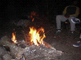 wasn’t
and he got lots of exercise paddling back to the campsite against the current.
wasn’t
and he got lots of exercise paddling back to the campsite against the current.
The campsite was great. As Dave was setting up his tent he came upon a small king snake or is it a poisonous coral snake? He yells out “How does it go? Red over yellow lovely fellow?” and the others come over to take a look. It was funny because the whole trip Dave kept telling everyone to be careful of snakes and he is the one who encounters one. The snake slithered away down an embankment and everyone finished setting up their tents. Dinner time, fire time, stories around the campfire, and finally sleeping time. Another great ending to another fantastic day. Once again we heard coyotes and owls during the night.
Today we launch a little earlier at
Still, we had current – our friend. Paddling felt
tougher and we had to dig down at times but I wouldn’t have wanted to be
anywhere else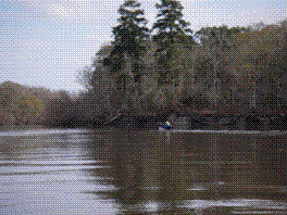 .
The scenery continued to treat us with its beauty and the stench from that
paper mill was slowly fading although at times you would get a whiff coming from
the water especially as you rounded a bend. Our goal today is to reach
Altamaha Fish Camp and then go another 7 miles to
.
The scenery continued to treat us with its beauty and the stench from that
paper mill was slowly fading although at times you would get a whiff coming from
the water especially as you rounded a bend. Our goal today is to reach
Altamaha Fish Camp and then go another 7 miles to
Stops on a convenient sandbar every two hours for a snack
and break were welcomed and something we did every day. Around
Day 4 33.8 miles
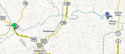
Studhorse Creek was easy to find since we had a GPS.
If you were paddling on river left, you probably would have seen it too but it
wasn’t that obvious until we 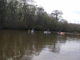 got
real close to it. I can see how someone unfamiliar with the area could
easily miss it.
got
real close to it. I can see how someone unfamiliar with the area could
easily miss it.
We enter the creek and it is very calm and narrower. Very nice – we are also protected from the wind and everything is still. Dave is using his map that he downloaded from Google and was getting a little worried. He leads the group toward the left when they hit an intersection because Dave thought it was a tributary that he saw on his map.
Something didn’t feel right especially when they were now
traveling northwest. Tom looks at his GPS and says “We’re now on
 We
were in
We
were in
We set up camp which goes very smoothly – nice having everyone on board with no issues. Dave and Sam want to try to hike to the old cypress trees they heard about. No one else wanted to join in because it was a hike through muddy marsh and we were told to take a compass or “you will get lost!” We make arrangements with Tom to blow his whistle if he hears us blowing ours just in case.
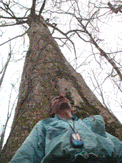 Sam
and Dave start hiking around 220 degrees per instructions from Danny – our
kayak shuttle guy. At first, it isn’t that bad – a little muddy but then
it started getting wetter and then squish, sink, we are in icky mud up to our
calves. We pick our way among what high ground we could find and try to
keep our course at 220. Sometimes the ground holds our weight and
sometimes we go right though into the mud. Maybe a little further than a
third of a mile, we see some bigger trees and a few white markers tied to
nearby trees. This must be it. The trees were big but they didn’t
stand out as humongous. It would take three or four people to stretch
their arms around the biggest one. Pretty cool and well worth the effort
to get there. Heck, this is an adventure anyway, isn’t it? We go
deeper into the woods and find other large, very old trees.
Sam
and Dave start hiking around 220 degrees per instructions from Danny – our
kayak shuttle guy. At first, it isn’t that bad – a little muddy but then
it started getting wetter and then squish, sink, we are in icky mud up to our
calves. We pick our way among what high ground we could find and try to
keep our course at 220. Sometimes the ground holds our weight and
sometimes we go right though into the mud. Maybe a little further than a
third of a mile, we see some bigger trees and a few white markers tied to
nearby trees. This must be it. The trees were big but they didn’t
stand out as humongous. It would take three or four people to stretch
their arms around the biggest one. Pretty cool and well worth the effort
to get there. Heck, this is an adventure anyway, isn’t it? We go
deeper into the woods and find other large, very old trees.
Time to head back and we figure it can’t be that bad so we try to back track without using the compass and get lost. No big deal so we stop, get our bearings and continue on. We are lost! Ok, let’s think. Oh yeah, we have a compass. So we take out the compass and have a few moments discussing how to read it in order to find 40 degrees to return to camp. Ok, let’s go. Remarkable! After a few minutes of hiking through the mud, following the compass, we find our original trail and hear and see camp. Sure glad we didn’t have to resort to blowing the whistle!
Back at camp we rinse off the mud in the river and then it is time to eat. After dinner we have yet another great fire – did I say how much these fires added to our trip? Across the river is a little stream heading northerly and we hear and see fish jumping. Wish we had a fishing pole. As the sun is setting we are around the fire, soaking in its warmth and see bats flying by - probably trying to catch bugs. That adds to our enjoyment of the moment. Another nice ending to another great day of our trip. We now have the extra mileage secured so we can really relax the next few days of paddling. After several hours enjoying the fire and sharing stories, we head to our tents for a well deserved good night’s sleep.
Today we have an easy 13 or 14-mile day so we take our time
getting up and end up launching around
Day 5 13.3 miles
We started at
Blue marker near Hwy 17 is MudCat Charlie’s where we had a very nice lunch.
The scenery was changing somewhat now with mixtures of reeds
lining the shoreline every now and then. We heard 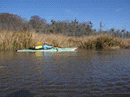 that
historically there were lots of rice fields in this area but none of us knew
enough to be able to pick out wild rice from the reeds. The whole trip we
were surprised and a little disappointed to have not seen an alligator.
This place is supposed to be crawling with them but due to the cold weather,
they must have been in hiding.
that
historically there were lots of rice fields in this area but none of us knew
enough to be able to pick out wild rice from the reeds. The whole trip we
were surprised and a little disappointed to have not seen an alligator.
This place is supposed to be crawling with them but due to the cold weather,
they must have been in hiding.
Today the wind is mostly at our backs (out of the west) indicating that a cold front did come through, although a weak one since it didn’t get significantly colder. As usual, we have a nice sunny day with cool temperatures. The paddle from our camp to Mudcat Charlies only took us two and a half hours. There weren’t many places we could get out at so we split up looking for spots. Getting out on the dock was an option but we wanted to see if there was an easier ramp. Jack and Dave find a muddy spot but if you paddled hard and glide up a bit, you could get out near shore with minimal mud. So they get out and walk on the board walk to tell the others they had found a spot. Much to their surprise, the others were already on the ramp – they had decided to just be careful and disembark on the floating ramp. This was the better of the two spots as we will see later.
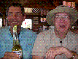 Mudcat
Charlie’s is located in a fish camp that has showers and caters to fishing
activities. Dave and Jack spend some time cleaning off the mud and
checking out the area. Hey, they sell beer at the grocery store! I
think Sam bought a six pack of Heineken and handed them out – I know I got one
– boy did that go down good! We’ll have to get some more for
tonight. Meanwhile, we get a table inside and asked if we were ok to come
in and they said “yes.” Lunch was great and the décor of the restaurant
was everything you’d hope for in a place on the river, in southern
Mudcat
Charlie’s is located in a fish camp that has showers and caters to fishing
activities. Dave and Jack spend some time cleaning off the mud and
checking out the area. Hey, they sell beer at the grocery store! I
think Sam bought a six pack of Heineken and handed them out – I know I got one
– boy did that go down good! We’ll have to get some more for
tonight. Meanwhile, we get a table inside and asked if we were ok to come
in and they said “yes.” Lunch was great and the décor of the restaurant
was everything you’d hope for in a place on the river, in southern
Well, lunch is over and we have around 4 miles to go to get to our campsite for the night. Stew, Tom, and Sam make their way back to their kayaks on the nice, clean floating dock while Jack and Dave make their way back to the muddy bank where they left their kayaks. What’s this? Boy are we stupid! We’ve been talking about how the tides are up to eight feet in this area and we knew the tide was going out so guess what? Jack and Dave’s kayaks are stranded on a mud bank with 20 feet or so of sticky, oozing mud to the water. Jack looks really disgusted while looking down from the board walk at the kayaks.
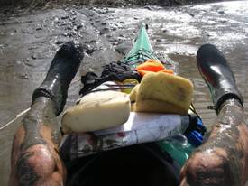 There
was only one option: lay flat on the front of the kayak with your legs
off the bow, kicking like a frog to propel you forward, arms flailing at
the mud and flounder toward the water through the mud. Then the tricky
part of inching to the cockpit, turning around and getting your butt into the
cockpit without capsizing while trying not to get too muddy but at that point,
it just didn’t matter anymore. Mud was everywhere. It must have
been hilarious to watch. As it turned out, we did get very muddy but it
was all part of the trip and we had a good laugh. Neither Jack nor Dave
fell in either which was an accomplishment in itself considering the
circumstances.
There
was only one option: lay flat on the front of the kayak with your legs
off the bow, kicking like a frog to propel you forward, arms flailing at
the mud and flounder toward the water through the mud. Then the tricky
part of inching to the cockpit, turning around and getting your butt into the
cockpit without capsizing while trying not to get too muddy but at that point,
it just didn’t matter anymore. Mud was everywhere. It must have
been hilarious to watch. As it turned out, we did get very muddy but it
was all part of the trip and we had a good laugh. Neither Jack nor Dave
fell in either which was an accomplishment in itself considering the
circumstances.
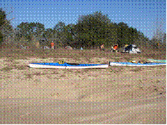
The paddle to Broughton Island from Mudcat Charlie’s was uneventful after the mud-launch. Tide was going out rather swiftly and it just pulled us to our destination. I must say that we really enjoyed our stay on Broughton Island. I know I want to plan a 3 or 4-day trip just to go back to Broughton Island for a few days. Big sand dunes, marsh area, and lots of places to explore. Setting up the tents was easy and we spent some time walking the island and just checking things out. Lots of animal foot prints and scat that we couldn’t figure out. Sam finally says “pigs!” and we concur. Pretty neat.

 Jack
decides that we should play Bocce Ball so we find some pieces of wood, pine
cones and fill some empty water bottles with sand. This was loads of fun
and one of the high points of our trip. We eat dinner and then are
treated to the most amazing sunset we had ever witnessed. The sky turned
colors of orange and reflected as a mirror would off the water. Our
photos don’t look real but they are. I wish I had a high quality camera
for those shots.
Jack
decides that we should play Bocce Ball so we find some pieces of wood, pine
cones and fill some empty water bottles with sand. This was loads of fun
and one of the high points of our trip. We eat dinner and then are
treated to the most amazing sunset we had ever witnessed. The sky turned
colors of orange and reflected as a mirror would off the water. Our
photos don’t look real but they are. I wish I had a high quality camera
for those shots.
 Sam
has another great fire all ready to go. Really takes the chill off and is
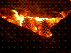
just great to hang out by and talk. There are lots of pine cones on the
island so we get a bunch and throw them in the fire – that made for some really
cool looking fire components too. The pine cones didn’t just turn to ash but
stayed around a while and glowed. Awesome.
We hit our tents around 10 pm and hear dolphin blowing (poosh!)as they search for food and large fish jumping. Around
midnight we hear dogs and people (hunters?) chasing pigs across the
sound. It was concerning at first because it sounded like it was on our
island and we didn’t want a hunting party plowing through our camp!
Sam
has another great fire all ready to go. Really takes the chill off and is
just great to hang out by and talk. There are lots of pine cones on the
island so we get a bunch and throw them in the fire – that made for some really
cool looking fire components too. The pine cones didn’t just turn to ash but
stayed around a while and glowed. Awesome.
We hit our tents around 10 pm and hear dolphin blowing (poosh!)as they search for food and large fish jumping. Around
midnight we hear dogs and people (hunters?) chasing pigs across the
sound. It was concerning at first because it sounded like it was on our
island and we didn’t want a hunting party plowing through our camp!
Ooooooh, its Friday the 13th! Today we have
yet another easy 13 or 14-mile day (wait until the story unfolds) so we take
our time getting up and allow some time to continue playing what we now call
“Modified Beach Bocce Ball.” We draw lines in the sand 15 paces or so
apart,  add
“throw from behind” lines, throw a pine cone that must cross the far line, then toss pieces of wood and plastic bottles filled with
sand to see who can end up closest to the pine cone after all throws.
Four people playing, two per team, standing on opposite sides and taking turns
throwing until a team gets 10 points. Lots of hooting,
razzing, and dancing when things go right. It really was a
blast!
add
“throw from behind” lines, throw a pine cone that must cross the far line, then toss pieces of wood and plastic bottles filled with
sand to see who can end up closest to the pine cone after all throws.
Four people playing, two per team, standing on opposite sides and taking turns
throwing until a team gets 10 points. Lots of hooting,
razzing, and dancing when things go right. It really was a
blast!
We were watching the tide and when it finally slowed down – it was coming in – we started getting ready to head out into the ocean. We launch right around 11 am and start heading east. Easy day, tide will help, no worries. Dave wished he had a better map – the ones from Google were ok but a real official chart would have made him feel better. Things didn’t look like what he expected but his trusty GPS was pointing the way. The current was a little against us to just going slack as we bid farewell to that great campsite on Broughton Island.
Day 6 27 miles
We paddled to Queen’s Island but didn’t find a good campsite
So we decided to continue in to Darien – the long way...
We paddle for 45 minutes or so and see markers that indicate
that we are on the Intracoastal Waterway route. That is good because we
wanted to go across the Altamaha Sound and follow Wolf Island out into the
Atlantic and the  waterway
was one of our landmarks. So we follow the markers while being sure we
are heading northeast to east and end up on Wolf Island, just east of the
Intracoastal Waterway. We stop for a quick break, stretch our legs and
eat lunch. Nice warm sun shining down on us making
it very pleasant.
waterway
was one of our landmarks. So we follow the markers while being sure we
are heading northeast to east and end up on Wolf Island, just east of the
Intracoastal Waterway. We stop for a quick break, stretch our legs and
eat lunch. Nice warm sun shining down on us making
it very pleasant.
We continue along Wolf Island heading east and make it into
the Atlantic Ocean right around 1 pm. We did it – 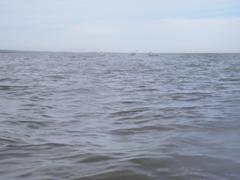 paddled
the entire Altamaha River! That was a nice feeling and
now let’s get to our next campsite so we can relax and maybe play some
more Beach Bocce Ball. We had some wind but the water was pretty much calm
and close to shore was brownish due to the current from the tides stirring up
the sand.
paddled
the entire Altamaha River! That was a nice feeling and
now let’s get to our next campsite so we can relax and maybe play some
more Beach Bocce Ball. We had some wind but the water was pretty much calm
and close to shore was brownish due to the current from the tides stirring up
the sand.
We arrive at Queen’s Island right around 2:15 pm – great timing – It will be nice to be early and set up camp so we can play and explore. The Sapelo Lighthouse is directly across the sound (Doboy Sound) about one mile from us and it is a treat to see a lighthouse since we don’t get to see many. We beach our kayaks and start looking for acceptable areas to set up our tents. The areas above the high tide marks are all oyster shells – not the best for pitching a tent on but maybe ok in a bind. We decide to go around the island to see if we can find a better campsite.
 Somehow
we missed a turn and ended up going further north and around Doboy Island which
is to the north of Queen’s Island. Still, no places to
camp. In the back of our minds we remembered hearing a weather
report that there will be rain that night as another cold front pushes
through. Some mild panic or rather we were just tired and wanted a place
to stop. We push on and cannot find an adequate place to camp and
somewhere in the odyssey we decide what the heck and start paddling in toward
Darien. What’s another 8 to 10 miles? Once it was decided we
relaxed again now knowing what we were going to do. The not knowing was
somewhat stressful but now we had a plan.
Somehow
we missed a turn and ended up going further north and around Doboy Island which
is to the north of Queen’s Island. Still, no places to
camp. In the back of our minds we remembered hearing a weather
report that there will be rain that night as another cold front pushes
through. Some mild panic or rather we were just tired and wanted a place
to stop. We push on and cannot find an adequate place to camp and
somewhere in the odyssey we decide what the heck and start paddling in toward
Darien. What’s another 8 to 10 miles? Once it was decided we
relaxed again now knowing what we were going to do. The not knowing was
somewhat stressful but now we had a plan.
We once again follow the waterway markers until we got to
the Darien River where we turned and went westerly toward Darien. We were
surprised to find several areas where the mud flats almost came all the way
across the river. Night was approaching fast and we knew we probably
wouldn’t make it before dark 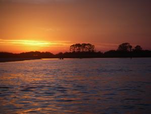 especially
with the tide still going out and making our progress slower. We also
were not prepared for paddling at night with regards to clothes – it was
getting chilly. Tom and Stew got their head lamps out and the rest of us
didn’t have them handy so we decided to stick close to the guys with the
lights. We were once again treated to a remarkable sunset at which time
everything seemed good again. So we have to paddle some in the dark –
maybe we can make it in as the last sunbeam disappears – and that we did.
especially
with the tide still going out and making our progress slower. We also
were not prepared for paddling at night with regards to clothes – it was
getting chilly. Tom and Stew got their head lamps out and the rest of us
didn’t have them handy so we decided to stick close to the guys with the
lights. We were once again treated to a remarkable sunset at which time
everything seemed good again. So we have to paddle some in the dark –
maybe we can make it in as the last sunbeam disappears – and that we did.
We arrived at the Darien boat ramp somewhere between 6:30 and 7:30 pm just as the last rays of the sun disappeared. I can’t remember the exact time because I was sooo cold at that point that I couldn’t think straight. I was in a wet bathing suit, had a wet cotton t-shirt on and a thin wind breaker over it. All of us were suffering as we pulled the kayaks out of the water and carried them up the asphalt ramp to a grassy area. We started unloading and getting everything ready to throw into our trucks/van while sometimes shivering uncontrollably. Luckily we had left our vehicles just up the ramp at the Sailfish Inn and - this is the very luckiest part – Scottie the owner of the inn happened to be there at the time. She fixed up rooms for us and gave us towels for our showers.
 We
threw everything in our vehicles and loaded the kayaks and went into the
Sailfish Inn for a nice hot shower. Everyone had a nice hot shower except
Dave – his shower was connected to a water heater that had just been turned on
and no hot water was available. So he took a cold shower and continued
shivering. Oh well. We all went to B and J’s for dinner – a great
place to eat if you like fresh shrimp and oysters. Their all you can eat
buffet is well worth it. An excellent dinner and back to the inn for a
good night’s rest. Sam and Dave walked down the road to Skipper’s bar and
had a nightcap – Sam bought Dave an Irish coffee and for the first time in many
hours, Dave felt warm. Ahhhhhhh!
We
threw everything in our vehicles and loaded the kayaks and went into the
Sailfish Inn for a nice hot shower. Everyone had a nice hot shower except
Dave – his shower was connected to a water heater that had just been turned on
and no hot water was available. So he took a cold shower and continued
shivering. Oh well. We all went to B and J’s for dinner – a great
place to eat if you like fresh shrimp and oysters. Their all you can eat
buffet is well worth it. An excellent dinner and back to the inn for a
good night’s rest. Sam and Dave walked down the road to Skipper’s bar and
had a nightcap – Sam bought Dave an Irish coffee and for the first time in many
hours, Dave felt warm. Ahhhhhhh!
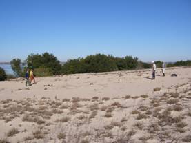
We got up the next day and ate breakfast at the inn.
Then we walked through town, looked at the scenery, and took some
pictures.
Great trip, great people, great adventure.
The End (for now!).
Kayak Info:
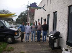
5 kayakers Sam 32, Dave 50, Stew 53, Tom 60 (he turned 60 week after trip), Jack 60 (turned 60 two weeks before trip)
Kayaks used (in same order as kayakers): QCC 500, Current Designs Solstice GTS, Current Designs Expedition, QCC 700, Current Designs Storm
Resources:
Do some research on the internet, post questions on
kayak/canoe forums to find out more about the
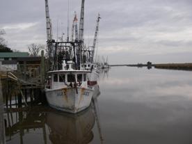
Darien, GA
The city has a website – informative – look it up on google.com
Sailfish Inn Bed and Breakfast ( look up on Google – they have a website)
We loved it – comfortable and homey – not luxurious but
everything we wanted. Great location. A block from the
Scottie
Darien, GA (912) 617-7299
Danny was very helpful and informative. We really enjoyed his company and service.
Kayak rental and shuttle service.
(912) 437-6010
Altamaha River Partnership www.altamahariver.org
We got a brochure that marks the boat ramps, places where you can resupply water, and gives mileage between points. We found it very useful for planning. Email them and ask for a brochure and/or see the tourism/visitor centers listed on the site and email or call to have copies sent to you.
Google Maps, Google Earth used in much of the planning for GPS coordinates as well as ideas of where to camp, eat, and lodging. Note that the maps printed out from Google are adequate but do not compare with the NOAA type maps. This area didn’t look too complicated so we didn’t get the official maps.
We also had a Delorme map of Georgia – it helped some but we really didn’t need it nor did we use it while on the trip.
IMPORTANT
Tides can be 8 feet near Darien and they are very swift! Get a tide chart at one of the fish camps or have the data previous to your trip by looking it up on the internet. Plan your paddles near the coast accordingly. The tides didn’t affect us much until we crossed east of I-95 but we heard they can impact you as far up as the Altamaha Fish Camp.